Jan. 2023 Science Corner | Increasing Wildfire Impacts on Snowpack at the Regional and Local Scale
In general, snowpack in forested areas can be enhanced or reduced by trees and vegetation. Trees protect snow from wind and sunlight so, in some places, when trees are removed the peak snow accumulation decreases. On the other hand, snowpack receives incoming longwave radiation from the atmosphere and surrounding trees, which can increase melt rates.
Authors: Stephanie Kampf, Daniel McGrath, Megan Sears, Steven Fassnacht, Leonie Kiewiet, and John Hammond
Interview and story by: Sabrina Chui, Project Associate
In recent decades, the western United States has experienced wildfires at increasing size and severity, often leaving large patches of high vegetation mortality. In the aftermath of these large fires, watersheds suffer from an array of issues leading to increased surface runoff and erosion, flooding, and water turbidity. Downstream agencies such as water utilities often struggle due to shifts in the timing of peak flows and large volumes of sediment deposition in their reservoirs. Less commonly discussed, however, are the impacts of wildfire on our natural water reservoir: snowpack. Snowpack in the western U.S. is critical for ecosystem function and water supply and, as wildfires burn more frequently in high elevation zones, there is an urgent need to understand how fires affect snowpack in different parts of the watershed.
In general, snowpack in forested areas can be enhanced or reduced by trees and vegetation. Trees protect snow from wind and sunlight so, in some places, when trees are removed the peak snow accumulation decreases. On the other hand, snowpack receives incoming longwave radiation from the atmosphere and surrounding trees, which can increase melt rates. Trees also intercept snowfall in their branches so in other locations, the snow accumulation increases when trees are removed. Vegetation removal through thinning or forest clearing have shown both positive and negative effects on snow-free dates. The snow-free date is defined as the last day of observed seasonal snow cover and a later snow-free date means water is being stored as snow and slowly released during the spring and summer, which is beneficial for our dry summers. Generally, fire as a disturbance tends to advance snow-free dates through vegetation removal and increased charred surfaces, but its effect on peak snowpack is highly variable both regionally and locally.
With this variability in mind, Dr. Stephanie Kampf and her coauthors wanted to investigate how wildfire impacts different parts of watersheds and quantify the spatiotemporal patterns of wildfires between western U.S. ecoregions and snow zones from 1984 to 2020. According to Dr. Kampf, the motivation for their paper “Increasing Wildfire Impacts on Snowpack in the Western U.S.” came after the 2020 Cameron Peak Fire that burned in northern Colorado. This was an unusual and important fire not only because of its size, but also because it burned at high elevation. The Cameron Peak fire created an opportunity to conduct field research on wildfire impacts in high elevation areas, and also raised the question of whether this was a pattern happening elsewhere in the western U.S.
First, Dr. Kampf and others mapped regional wildfire trends over snow zones by using existing data sets of wildfire boundaries from 1984 to 2019 and defining snow zones by mean annual snow-free dates computed from MODIS satellite snow cover, categorizing these zones into low snow zone: earlier than March 1, early zone: 1-31 March, middle zone: 1-30 April, and late zone: May 1 or later. They then computed the annual area burned in each snow zone and ecoregion as well as the annual fraction of area burned within each snow zone and region to capture these regional trends.
At the same time, a field study compared snowpack in burned and unburned locations in middle-late zones (mean annual melt earlier than May 15) and late zones (mean annual melt later than May 15). Automated snow depth monitoring stations and monthly snow surveys were used to measure snow depth and snow water equivalent (SWE), the amount of liquid water in the snow, over the winter season.
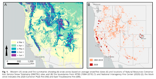
The results from the mapping study show trends of wildfires encroaching on later snow zones. Between 1984 and 2020, wildfire areas have been increasing in nearly all mountain ranges across the western U.S., with the highest rates of increase in the Sierra Nevada. Most concerning was the finding that 70% of the ecoregions examined had significant increases in wildfire area in the late snow zone. Essentially, wildfires are increasing in higher elevation areas that typically have larger snowpacks and store more water.
At the watershed level, analysis from the field study revealed that there was earlier melt in burned areas compared to unburned areas, with a greater advance in snow-free dates in the middle-late snow zone compared to the late snow zone. The greater impact on earlier snow zones was largely attributed to snowfall frequency and quantity. The soot and debris that accumulates post-fire decreases the albedo (how much light is being reflected) of the snow surface, which tends to increase melt rates, but these soot layers can also be covered by snow. The late snow zone site received twice as much precipitation as the middle-late snow zone site, including more snow in the late winter season, so the soot layers were not as frequently exposed at the snow surface.
Dr. Kampf and her colleagues specifically highlight how different snow zones are affected differently by wildfire, providing a more nuanced understanding of how wildfire impacts watersheds at different elevations.
At Blue Forest, a large component of our work involves quantifying and projecting the benefits of forest health treatments. We are constantly seeking better models, better data, and better science to inform our approach to motivate beneficiaries such as water and power utilities to invest in watershed health – what we call natural infrastructure. Studies like Dr. Kampf’s add to our current understanding of the complex relationships between fire, snowpack, and our precious water supply, with implications for how we should approach management. For example, Dr. Kampf suggests prioritizing work in low to mid snow zones, as these areas right at the margin of seasonal snowpack are where potential advances in snow-free dates could be most significant. Practically, these areas also tend to overlap with wildland urban interfaces (WUIs) and tend to have more opportunities to get restoration treatments on the ground due to the longer working season.
Looking ahead, Dr. Kampf and her colleagues will continue studying the Cameron Peak fire, delving into how other hydrological variables such as streamflow and erosion have been affected post-fire as well as research wildfire impacts on hydrology in other parts of the world. As Dr. Kampf says, “what’s really important is for people to be aware that there are these trends towards larger wildfires in places with a lot of snow. That is definitely going to influence the snow, and it already is influencing the snow. But we are not very well set up to understand what that influence is.”
So far, existing snowpack studies that involve field data are very site-specific, because it is extremely time- and labor-intensive to collect snow depth and SWE data. But with existing datasets and advances in technology such as remote sensing, studies can be designed in a “thoughtful and strategic way” to make the most of resources. What Dr. Kampf hopes the audience will gain from this study is “not necessarily a one-size-fits-all answer about wildfire effects on snowpack, but rather a way of examining these effects that will help us get those answers in the future.”