Feb. 2024 Science Corner | A framework to restore estuarine habitats and safeguard ecosystem benefits in a dynamic intracoastal waterway
In this article, the authors outline a process for identifying ecosystem restoration interventions, such as living shorelines and mangrove establishment, that help wetlands keep pace with rising sea levels.
Authors: Gregg Verutes, Philip Yang, Scott Eastman, Cheryl Doughty, Tess Adgie, Kaitlyn Dietz, Nikki Dix, Ali North, Greg Guannel & Sam Chapman
Science Corner by: Gregg Verutes, Ph.D.
Photo credits: Sam Chapman and Adam Langley
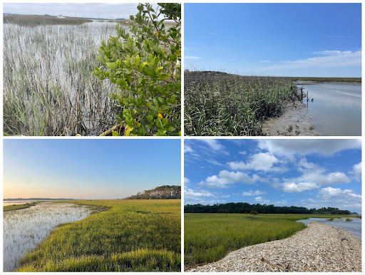
As coastal ecosystems experience impacts from rising seas and more intense storms, land managers must explore a suite of proactive techniques to promote wetland resilience. Coastal wetland position relative to sea level is maintained by surface elevation and driven by accretion, an accumulation of sediment, and plant roots. Northeastern Florida has some of the most intact estuarine habitats in the southeastern US, and maintaining their ability to protect human populations and ecosystem benefits is essential for resilience planning.
Blue Forest science team member Gregg Verutes, Ph.D., worked alongside an interdisciplinary group of scientists, reserve managers, and restoration specialists to understand how management options might help maintain or increase coastal wetland surface elevation. These efforts resulted in a new study published in the PeerJ this month. In this article, the authors outline a process for identifying ecosystem restoration interventions, such as living shorelines and mangrove establishment, that help wetlands keep pace with rising sea levels. The team piloted this framework with stakeholders in the Guana Tolomato Matanzas National Estuarine Research Reserve (GTMNERR) near Saint Augustine, Florida.
The GTMNERR salt marshes are similar to others globally. They are vulnerable to human and climate pressures acting simultaneously and threatening ecosystem benefits such as flood protection, blue carbon sequestration, recreation, and wildlife viewing opportunities. In 2020, GTMNERR released a set of management needs used by the NERRS Science Collaborative to solicit research proposals. Recognizing the dynamic nature of their coastline and the increasing human population in Northeast Florida, the Reserve prioritized research on the “impacts of climate, dredging, shoreline armoring, and sand placement on nearshore and estuarine structure and function, and the ecosystem benefits and tradeoffs of different management options.”
The region is seeing an increase in tropical mangroves due to climate change, and understanding this dynamic vegetation shift is critical for future wetland resilience. Additionally, coastal managers identified boat wakes as a primary driver of flooding and erosion impacts on its wetlands. To address this knowledge gap, the team analyzed satellite imagery, conducted interviews, and identified spatial trends in vessel traffic data to update the habitat maps and estimate boat wake exposure. An existing coastal risk reduction assessment tool was then adapted to the GTMNERR context to include elevation vulnerability and thus identify wetland hotspots susceptible to inundation by rising water levels and frequent big storms.
“We have been fortunate to work with the land managers and scientists of the GTMNERR and other local agencies since the inception of our projects,” said Dr. Sam Chapman, a principal investigator who teaches biology at Villanova University. “From the outset, we surveyed science gaps that stakeholders needed to be filled. As is common with applied science, one question led to another, and our understanding of drivers of coastal wetland resilience led us to investigate boat wakes and other potential drivers of ponding and erosion.”
A key outcome of the approach lies in the process of engagement. To ensure the research addressed the most pressing needs and filled knowledge gaps, the authors hosted a series of workshops and site visits with subject matter experts to hear restoration stories and lessons from the field. It became clear that some restoration options in specific locations could help habitats maintain their normal patterns of nutrient cycling, filtration, elevation maintenance, and other ecosystem services following disturbance. This engagement enabled the Reserve to prioritize evaluating sites of concern and consider the potential of four wetland elevation strategies for flood protection and other ecosystem co-benefits at these sites. Findings are available via the project website and mapping tool.